It’s time to recalibrate the navigation systems on ships, airplanes, as the position of the magnetic North Pole is officially being changed, continuing its shift away from Canada and towards Siberia.
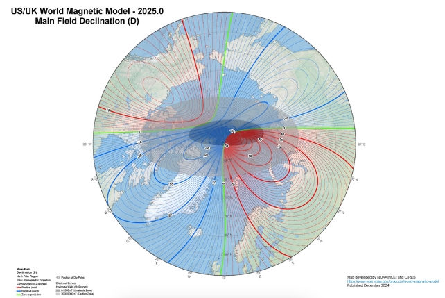
Experts from the US National Oceanic and Atmospheric Administration (NOAA) and the British Geological Survey (BGS) have joined forces – as they do every five years – to produce a new, more accurate World Magnetic Model (WMM).
While the geographical North Pole stays fixed in place (at the very summit of the Earth’s rotational axis), the WMM pinpoints the magnetic North Pole – where Earth’s magnetic field points straight down, a perfectly vertical magnetic field.
And as the iron and nickel inside our planet shift, so does Earth’s magnetic field, meaning the North (and South) Poles are also constantly on the move. If you’re using a compass or a GPS system, knowing exactly where these points are is crucial.
“The current behaviour of magnetic north is something that we have never observed before,” says global geomagnetic field modeller William Brown, from BGS.
“Magnetic north has been moving slowly around Canada since the 1500s but, in the past 20 years, it accelerated towards Siberia, increasing in speed every year until about five years ago, when it suddenly decelerated from 50 to 35 kilometers [31 to 22 miles] per year, which is the biggest deceleration in speed we’ve ever seen.”
Research suggests that two giant magnetic lobes – one under Canada and one under Siberia – are what’s driving the shifting of magnetic north. Sometimes the shifts are dramatic enough that an emergency update is required, outside of the usual 5-year cycle.
Now we have a more accurate map of magnetic north, one that should be good for another half a decade.

For the first time, a higher resolution map is also available, which offers more than 10 times more detail: it has a spatial resolution of about 300 km at the equator compared to the standard 3,300 km.
According to the BGS team, traveling 8,500 km (5,282 miles) from South Africa to the UK in a straight line would leave you 150 km (93 miles) off course by the end, if you used the old WMM compared to the new WMM for your navigation.
That’s how much difference it can make, and mapping and logistics companies, together with governments and official agencies, will be making updates.
“Major airlines will upgrade the navigation software across their entire fleets of aircraft to load in the new model, and militaries in NATO will need to upgrade software in a huge number of complex navigation systems across all kinds of equipment,” Brown told Mindy Weisberger at CNN.
🚨 The World Magnetic Model 2025 is now live. Deployed on December 31st to all Flight Service platforms, this update ensures you’re heading in the right direction for the new year! 😉 Potential Impacts: Aeronautical charts 🗺️ , runway numbers 🛬, and navigation systems 🧭. pic.twitter.com/zFmgAG5xh2
— Flight Service ✈️ (@1800wxbrief) January 7, 2025
However, we won’t have to apply any updates to our own phones or sat navs – it’ll all happen automatically.
The magnetic North Pole was first discovered by Sir James Clark Ross in northern Canada back in 1831.
Since then, researchers have gradually been able to track it with more precision, using ground measurements taken all across the globe as well as readings from satellites in space.
An earlier version of this article was published in December 2024.


