For much of the 65,000 years of Australia’s human history, the now-submerged northwest continental shelf connected the Kimberley and western Arnhem Land. This vast, habitable realm covered nearly 390,000 square kilometres, an area one-and-a-half times larger than New Zealand is today.
It was likely a single cultural zone, with similarities in ground stone-axe technology, styles of rock art, and languages found by archaeologists in the Kimberley and Arnhem Land.
There is plenty of archaeological evidence humans once lived on continental shelves – areas that are now submerged – all around the world. Such hard evidence has been retrieved from underwater sites in the North Sea, Baltic Sea and Mediterranean Sea, and along the coasts of North and South America, South Africa and Australia.
In a newly published study in Quaternary Science Reviews, we reveal details of the complex landscape that existed on the Northwest Shelf of Australia. It was unlike any landscape found on our continent today.
A continental split
Around 18,000 years ago, the last ice age ended. Subsequent warming caused sea levels to rise and drown huge areas of the world’s continents. This process split the supercontinent of Sahul into New Guinea and Australia, and cut Tasmania off from the mainland.
Unlike in the rest of the world, the now-drowned continental shelves of Australia were thought to be environmentally unproductive and little used by First Nations peoples.
But mounting archaeological evidence shows this assumption is incorrect. Many large islands off Australia’s coast – islands that once formed part of the continental shelves – show signs of occupation before sea levels rose.
US Geological Survey, Geoscience Australia
Stone tools have also recently been found on the sea floor off the coast of the Pilbara region of Western Australia.
However, archaeologists have only been able to speculate about the nature of the drowned landscapes people roamed before the end of the last ice age, and the size of their populations.
Our new research on the Northwest Shelf fills in some of those details. This area contained archipelagos, lakes, rivers and a large inland sea.

US Geological Survey, Geoscience Australia
Mapping an ancient landscape
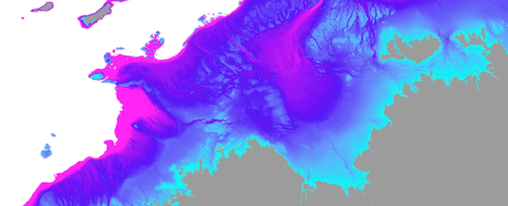
To characterise how the Northwest Shelf landscapes changed through the last 65,000 years of human history, we projected past sea levels onto high-resolution maps of the ocean floor.
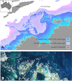
We found low sea levels exposed a vast archipelago of islands on the Northwest Shelf of Sahul, extending 500km towards the Indonesian island of Timor. The archipelago appeared between 70,000 and 61,000 years ago, and remained stable for around 9,000 years.
Thanks to the rich ecosystems of these islands, people may have migrated in stages from Indonesia to Australia, using the archipelago as stepping stones.
With descent into the last ice age, polar ice caps grew and sea levels dropped by up to 120 metres. This fully exposed the shelf for the first time in 100,000 years.
The region contained a mosaic of habitable fresh and saltwater environments. The most salient of these features was the Malita inland sea.
Our projections show it existed for 10,000 years (27,000 to 17,000 years ago), with a surface area greater than 18,000 square kilometres. The closest example in the world today is the Sea of Marmara in Turkey.
We found the Northwest Shelf also contained a large lake during the last ice age, only 30km north of the modern day Kimberley coastline. At its maximum extent it would have been half the size of Kati Thandi (Lake Eyre). Many ancient river channels are still visible on the ocean floor maps. These would have flowed into Malita sea and the lake.
A thriving population
A previous study suggested the population of Sahul could have grown to millions of people.
Our ecological modelling reveals the now-drowned Northwest Shelf could have supported between 50,000 and 500,000 people at various times over the last 65,000 years. The population would have peaked at the height of the last ice age about 20,000 years ago, when the entire shelf was dry land.
This finding is supported by new genetic research indicating large populations at this time, based on data from people living in the Tiwi Islands just to the east of the Northwest Shelf.
At the end of the last ice age, rising sea levels drowned the shelf, compelling people to fall back as waters encroached on once-productive landscapes.
Retreating populations would have been forced together as available land shrank. New rock art styles appeared at this time in both the Kimberley and Arnhem Land.
Rising sea levels and the drowning of the landscape is also recorded in the oral histories of First Nations people from all around the coastal margin, thought to have been passed down for over 10,000 years.
This latest revelation of the complex and intricate dynamics of First Nations people responding to rapidly changing climates lends growing weight to the call for more Indigenous-led environmental management in this country and elsewhere.
As we face an uncertain future together, deep-time Indigenous knowledge and experience will be essential for successful adaptation.![]()
Kasih Norman, Research Fellow, Griffith University; Chris Clarkson, Professor in Archaeology, The University of Queensland; Corey J. A. Bradshaw, Matthew Flinders Professor of Global Ecology and Models Theme Leader for the ARC Centre of Excellence for Australian Biodiversity and Heritage, Flinders University; Frédérik Saltré, Research Fellow in Ecology for the ARC Centre of Excellence for Australian Biodiversity and Heritage, Flinders University, and Tristen Anne Norrie Jones, Academic Fellow, University of Sydney
This article is republished from The Conversation under a Creative Commons license. Read the original article.


